![]()
Regional Official Plan Amendment No. 49 - Notice of Adoption
On November 4, 2022, the Minister of Municipal Affairs and Housing approved Regional Official Plan Amendment No. 49 (ROPA 49) with forty-five modifications as part of the Municipal Comprehensive Review. This amendment is made under Section 26 of the Planning Act, R.S.O. 1990.
The Minister’s decision maintains Regional Council’s vision for Halton’s Urban Structure where a significant share of the growth in Halton will occur as adopted by Regional Council, but alters the Amendment to include expanding the Regional Urban Boundary with additional new lands to accommodate population and employment growth to 2051. The decision also provides direction for the Integrated Growth Management Strategy, which will help the Region plan for future population and job growth as mandated by A Place to Grow: Growth Plan for the Greater Golden Horseshoe (external link) under the Places to Grow Act, 2005.
About Regional Official Plan Amendment 49
The purpose of this Amendment is to implement the results of the Region’s Integrated Growth Management Strategy (IGMS). This strategy considers how to accommodate growth in Halton to the year 2051 as part of the Municipal Comprehensive Review process. The Amendment implements Regional Council’s direction to:
- accommodate population and employment growth within Halton’s existing Regional Urban Boundary to 2041; and
- develop a framework for planning for growth from 2041 to 2051.
The Amendment also provides changes to achieve conformity with the Provincial Growth Plan for the Greater Golden Horseshoe. Among other things, this includes updates to policies and mapping related to:
- existing Settlement Area boundaries;
- the Regional Urban Structure;
- Strategic Growth Areas; and
- Employment Areas.
It also includes updated forecasts and targets for population and employment growth, intensification, density and Regional phasing.
What are settlement areas?
These are urban areas and rural communities where development is already concentrated and which have a mix of land uses. Focusing growth in settlement areas helps protect our natural heritage system and preserve agricultural lands.
The current Regional Official Plan guides growth and development to the year 2031. All upper- and single-tier municipalities that are subject to 'A Place to Grow: The Growth Plan for the Greater Golden Horseshoe, 2019 (external link)', prepared under the Places to Grow Act, 2005, must plan to accommodate population and employment growth projected to 2051. For Halton Region, this represents an additional 332,000 people and 150,000 jobs.
The Integrated Growth Management Strategy (IGMS) has been an important part of the ROPR process, which was initiated by Halton in 2014. Following an overall Directions Report in 2016 and the consideration of subsequent changes to the Provincial planning framework, significant analysis and consultation was undertaken in developing a series of milestone IGMS reports.
A Regional Urban Structure Discussion Paper was presented to Regional Council as part of a series of ROPR theme area discussion papers in July 2020. The paper addressed:
- the importance of directing growth to key locations within the Region’s existing urban areas;
- implementing the requirements of the Provincial Growth Plan; and
- supporting Local Municipal Plans and Priorities.
Consultations were held on the discussion paper with Local Municipalities, agencies and the public in 2020.
What is an Urban Structure?
An urban structure is how the land use of a region, city or town is determined. It guides how and where our community develops buildings, spaces or municipal infrastructure as Halton grows. An urban structure can consist of:
- residential areas;
- employment areas;
- strategic growth areas; and
- transportation and growth corridors that connect these areas.
The Regional Urban Structure Discussion Paper and consultations identified strong support for directing higher-density, transit-supportive growth to key areas in Halton Region, namely around GO Transit Stations and existing or planned transit corridors.
Regional Council directed staff to develop an initial scoped Regional Official Plan Amendment (ROPA 48) to advance select local municipal planning priorities related to urban structure. ROPA 48 was adopted by Regional Council in July 2021 and approved by the Province in November 2021. The Regional Urban Structure will help plan for a significant share of the growth in Halton, forming an integral part of Halton’s growth strategy.
In 2019 and 2020, Regional Council received information on a set of Growth Scenarios (external PDF). These scenarios were developed to assess a range of approaches to accommodate growth in Halton. The Growth Scenarios and the Evaluation Framework (external PDF) set a strong foundation for the IGMS by highlighting the importance of:
- advancing local plans and priorities; and
- identifying objectives and measures to use when evaluating options for how Halton could grow.
What are Strategic Growth Areas?
These are areas where population and job growth will be focused. They include areas such as:
- Urban Growth Centres;
- Major Transit Station Areas;
- Regional Nodes; and
- Intensification Corridors.
Building on the direction from Regional Council in response to the Growth Scenarios and Evaluation Framework, Regional staff prepared a Growth Concepts Discussion Paper. The paper identified and evaluated different approaches to accommodating growth in Halton to the year 2051 using the endorsed Evaluation Framework. By identifying the distinctions between each approach, the Region was able to gather valuable input from Local Municipalities, public agencies and the public.
On November 17, 2021 and February 9, 2022, Council Workshops were held to provide Regional Council and the public with information on a Draft Preferred Growth Concept prepared by Regional staff based on the IGMS work to date. The Workshops provided an overview of the evaluated Growth Concepts, a summary of the public engagement process and the feedback received from the public, Advisory Committees and Local Municipalities.
At its February 16, 2022 meeting, Regional Council adopted a motion directing staff to prepare a Regional Official Plan Amendment to implement a Modified Preferred Growth Concept that advances growth in Halton to 2051 in two phases:
- for growth prior to 2041, where population and employment growth will be directed to the existing approved urban boundary; and
- for growth between 2041 and 2051, where a clear framework is provided for when and how planned growth will be distributed based on principles of minimizing land consumption, making the most efficient use of land and infrastructure, and achieving other principles of the Growth Plan.
The motion also stated that:
- the framework is to consider the findings of the Provincial Affordable Housing Task Force, Natural Heritage and Water Resources Impact Assessment and Agricultural Impact Assessment; and
- growth post-2041 will be defined in detail through a ROPA prior to, or in parallel with, the next statutory five-year official plan review.
ROPA 49 proposes to update the Regional Official Plan to incorporate this Council direction in alignment with Provincial policies.
Updates to the Regional Official Plan
ROPA 49 updates the current Regional Official Plan by revising or adding the following elements:
1. Planning for Population and Employment Growth
Halton’s Regional Official Plan determines how and when Halton grows. The Region’s growth strategy currently plans to the year 2031.
What is changing?
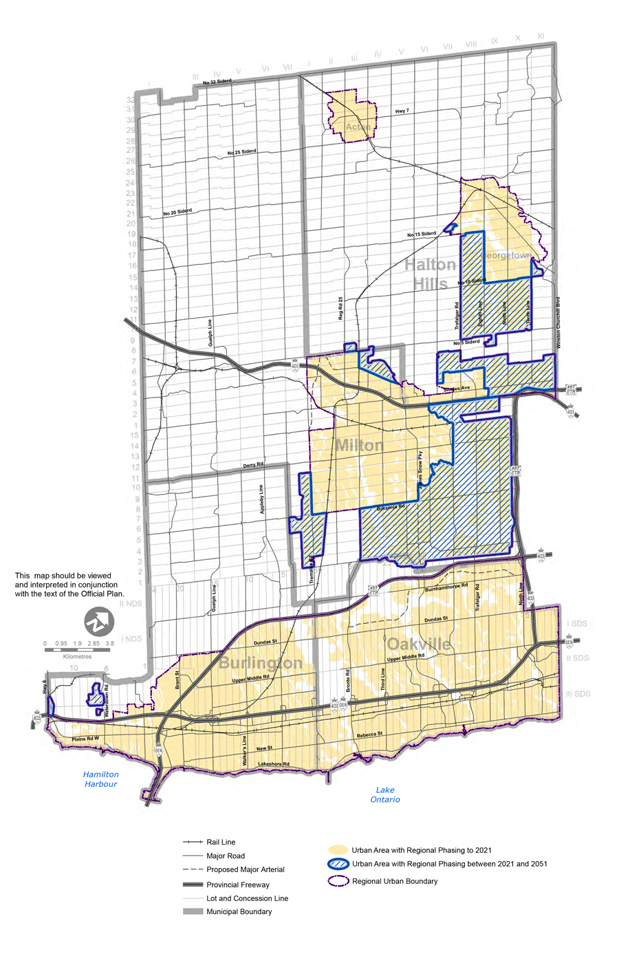
ROPA 49 updates Halton Region’s growth strategy to plan for how growth is accommodated to 2051. The updated Regional Official Plan accommodates population and employment growth by expanding the Regional Urban Boundary to add new community lands and employment lands in Halton. Table 1 identifies how growth will be allocated amongst the four Local Municipalities.
| Municipality |
Population 2021 |
Population 2041 |
Population 2051 |
Employment 2021 |
Employment 2041 |
Employment 2051 |
|
Burlington
|
195,000
|
240,050
|
265,160
|
98,340
|
114,330
|
124,390
|
|
Oakville
|
220,000
|
313,460
|
349,990
|
111,980
|
160,880
|
181,120
|
|
Milton
|
137,980
|
277,000
|
350,870
|
44,390
|
100,120
|
136,270
|
|
Halton Hills
|
66,010
|
98,890
|
132,050
|
24,510
|
45,900
|
65,460
|
|
Halton Region
|
620,990
|
929,400
|
1,098,070
|
279,220
|
421,230
|
507,240
|
2. Updates to Intensification and Density Targets
The Regional Official Plan contains forecasts and targets for population and employment growth, intensification, density, and Regional phasing to support its growth strategy.
What is changing?
ROPA 49 revises a series of targets applied at a range of geographic scales to accommodate growth in Halton by expanding the existing Regional Urban Boundary.
The Built-up Area intensification rate determines the proportion of housing units which must be built within the Built Boundary annually. The Region-wide target is revised to 45 per cent under ROPA 49. This is a lower alternative target than contained in the Growth Plan. The lower target supports greater densification in existing Designated Greenfield Areas which is consistent with the ‘intensification first’ objectives of the Growth Plan and limits the need for urban boundary expansion.
As a result of the Minister’s modifications to ROPA 49, Table 2 (Intensification and Density Targets) and Table 2a (Regional Phasing) will be updated to the 2051 planning horizon through a future Amendment to the Regional Official Plan as a part of the Municipal Comprehensive Review. In support of the ‘intensification first’ approach, Table 2 will include not only the Intensification Target by Local Municipality, but also a Designated Greenfield Area Density Target and an Employment Area Density Target.
Table 2a (Regional Phasing) will also be updated through a future amendment to provide general direction on how growth allocated under Table 1 is to be planned for in each Local Municipality with further detail for Strategic Growth Areas provided in Table 2b.
ROPA 48 introduced Table 2B (Strategic Growth Area Targets) to include minimum density targets for jobs and residents as well as general target ratios for jobs and residents for certain Strategic Growth Areas. ROPA 49 updates Table 2b to include targets for all Primary Regional Nodes as well as Milton-Trafalgar GO MTSA, which were not previously delineated in the Regional Official Plan and are described in the following sections.
|
Strategic Growth Area
|
Minimum Density Target*
(Residents and Jobs Combined Per Hectare)
|
Residents
|
Jobs
|
|
Urban Growth Centres/Major Tranit Station Areas on a Priority Transit Corridor
|
|
Midtown Oakville/Oakville Go
|
200
|
65%
|
35%
|
|
Downtown Burlington/Burlington Go
|
200
|
65%
|
35%
|
|
Urban Growth Centres/Major Transit Station Areas on a Commuter Rail Corridor
|
|
Downtown Milton/Milton Go
|
200
|
80%
|
20%
|
|
Major Transit Station Areas on a Priority Transit Corridor
|
|
Bronte GO
|
150
|
40%
|
60%
|
|
Appleby GO
|
120
|
40%
|
60%
|
|
Major Transit Station Areas on a Commuter Rail Corridor
|
|
Aldershot GO
|
150
|
80%
|
20%
|
|
Milton-Trafalgar GO
|
150
|
TBD
|
TBD
|
|
Georgetown GO
|
TBD
|
TBD
|
TBD
|
|
Acton GO
|
TBD
|
TBD
|
TBD
|
|
Primary Regional Nodes
|
|
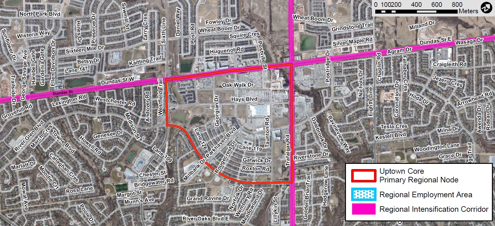
Uptown Core, Oakville
|
160
|
85%
|
15%
|
|
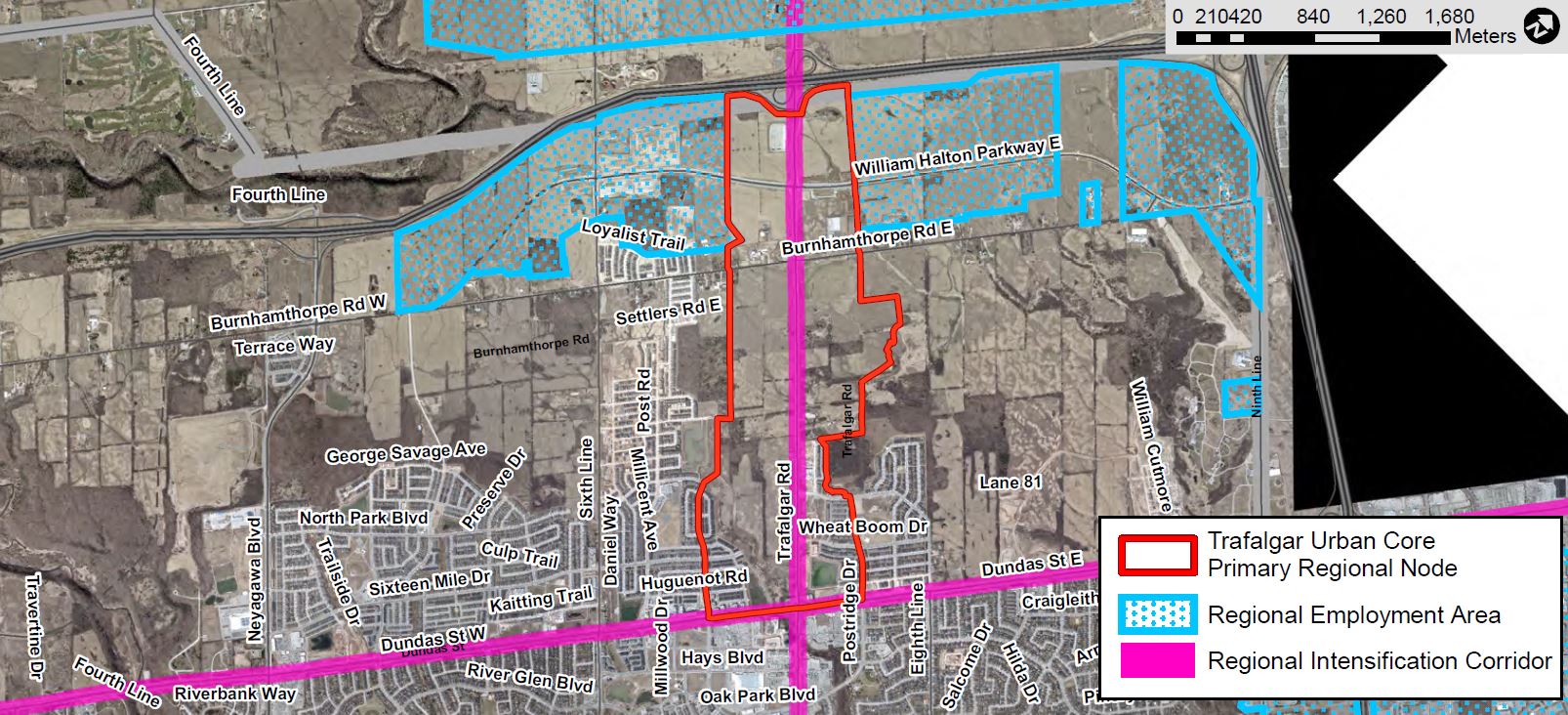
Trafalgar Urban Core, Oakville
|
160
|
85%
|
15%
|
|
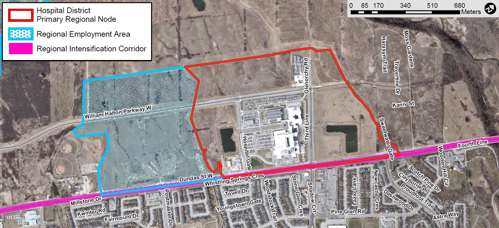
Hospital District, Oakville
|
160
|
40%
|
60%
|
|
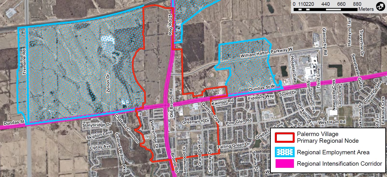
Palermo Village, Oakville
|
160
|
85%
|
15%
|
|
Neyagawa Urban Core, Oakville
|
160
|
85%
|
15%
|
|
Dundas Urban Core, Oakville
|
160
|
85%
|
15%
|
|
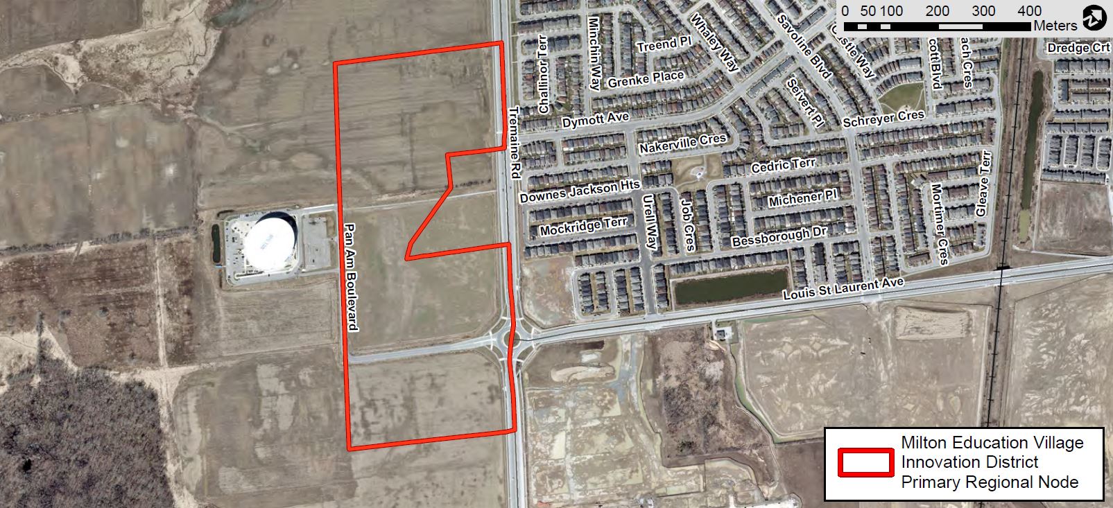
Milton Education Village Innovation District
|
130
|
55%
|
45%
|
3. Major Transit Station Areas
ROPA 48 updated the Regional Official Plan by delineating Major Transit Station Areas to ensure conformity with the Growth Plan, 2019 and to provide direction for Local Municipalities to implement area-specific plans for these important Strategic Growth Areas:
- Midtown Oakville GO UGC/MTSA
- Downtown Burlington UGC/Burlington GO MTSA
- Milton GO UGC/MTSA
- Aldershot GO MTSA
- Appleby GO MTSA
- Bronte GO MTSA
- Georgetown GO MTSA
- Acton GO MTSA
What are Major Transit Station Areas?
These are the areas within a 500 to 800-metre radius (about a 10-minute walk) from a major transit station. They are primarily located along existing or planned transit corridors.
Major Transit Station Areas are intended to be developed as higher density, mixed-use communities. These areas enable people to rely on transit to access local amenities, housing and work.
What is changing?
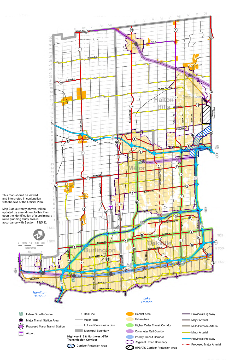
ROPA 49 builds on the framework introduced under ROPA 48 and identifies and delineates an additional Major Transit Station Area: Milton-Trafalgar GO (see Map 6i).
Consideration is being given to the Agerton area near Steeles Avenue and Trafalgar Road in the Town of Milton. The area is identified as a priority for growth by the Town of Milton and contains the location of a future GO Transit Station and a Major Transit Station Area (MTSA).
Given the location of the Agerton Lands to be identified within an MTSA, their role as part of the Regional Urban Structure, their potential to accommodate high-density mixed use development supportive of investments in transit and existing infrastructure, and their current use as a rail yard owned by Canadian Pacific Railway, considering the inclusion of these lands within the Regional Urban Boundary may be warranted, subject to further direction from Regional Council.
Mapping for all other Major Transit Station and Urban Growth Centre areas is also updated to delineate Regional Corridors and changes to the Regional Employment Area resulting from conversions and additions.
Map 6i – Milton-Trafalgar GO (NEW)
4. Primary Regional Nodes
ROPA 48 updated the Regional Official Plan by identifying Primary and Secondary Regional Nodes on Map 1H. Through their decision, the Minister of Municipal Affairs and Housing made modifications to these policies, which are revised by ROPA 49.
What are Regional Nodes?
These are strategic growth areas which have a role in accommodating mixed-use intensification and supporting the regional transit network.
What is changing?
ROPA 49 updates the policy framework associated with Primary Regional Nodes by delineating and assigning targets to these Strategic Growth Areas. Halton’s Local Municipalities are required to plan for growth in these locations in accordance with targets listed under Table 2B. Halton’s Local Municipalities are encouraged to set density and employment targets for Secondary Regional Nodes which are not currently delineated.
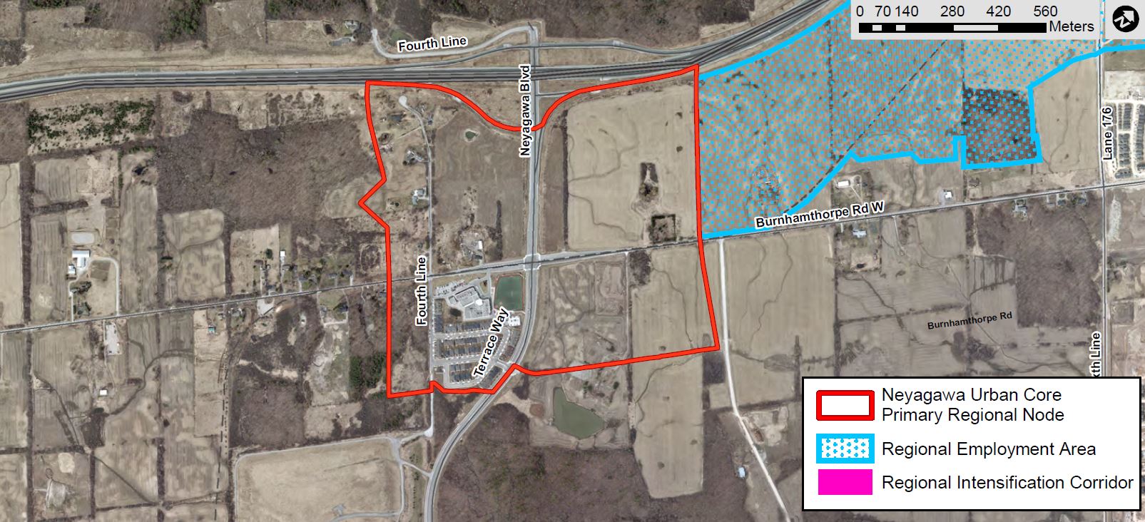
ROPA 49 adds two new Primary Regional Nodes in Oakville (Hospital District and Palermo Village) and identifies Neyagawa Urban Core as a Primary Regional Node rather than a Secondary Node. ROPA 49 also identifies Burlington Uptown Urban Centre as a Secondary Regional Node rather than as a Primary Regional Node.
Map 1H is updated to delineate all Primary Regional Nodes and continues to identify all Primary Regional Nodes as symbols. Detailed mapping for all other Primary Regional Nodes is also updated to delineate Regional Corridors and changes to the Regional Employment Area resulting from conversions and additions.
Map 6j – Uptown Core Primary Regional Node
Map 6k – Trafalgar Urban Core Primary Regional Node
Map 6l– Hospital District Primary Regional Node (NEW)
Map 6m – Palermo Village Primary Regional Node (NEW)
Map 6n – Neyagawa Urban Core Primary Regional Node (NEW – Formerly a Secondary Regional Node)
Map 6p – Milton Education Village Innovation District Primary Regional Node
5. Regional Intensification Corridors
ROPA 48 identified Regional Corridors within the hierarchy of Strategic Growth Areas. It also provided updates to objectives and mapping to recognize the role of these corridors in the Regional Urban Structure.
What are Regional Intensification Corridors?
These are Strategic Growth Areas identified along major roads, arterials or higher order transit corridors.
These areas are planned to accommodate a significant amount of growth to provide access to frequent transit and support future transit projects.
What is changing?
ROPA 49 updates policies for these important Strategic Growth Areas and renames them Regional Intensification Corridors. These updates support the corridors’ role in accommodating growth in the Urban Area along routes connecting Regional Nodes, Major Transit Station Areas and Urban Growth Centres.
Specific density targets are not set for these areas. The Regional Plan will, however, contain policies requiring these areas to be planned to accommodate growth at a scale appropriate for their context and existing and planned transit service.
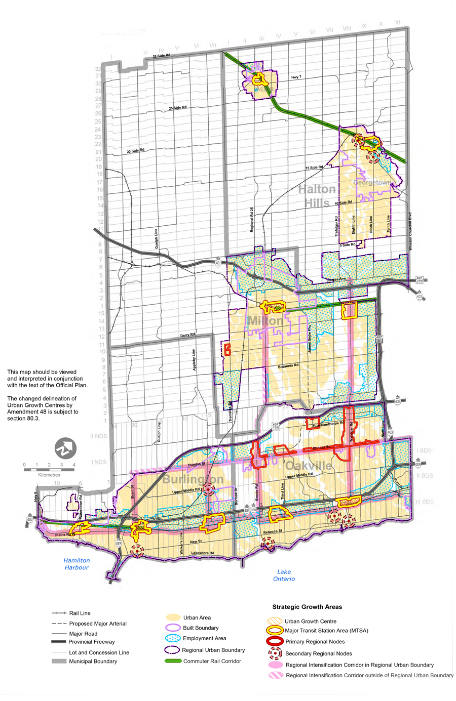
Map 1H – Regional Urban Structure
6. Additional Residential Units
Currently, the Regional Official Plan contains few policies related to permitting additional residential units within an existing dwelling in a residential neighbourhood.
What is an Additional Residential Unit?
These are self-contained separate dwelling units with full kitchens and bath facilities as part of an existing detached, semi-detached or row house, or in a structure ancillary to a detached, semi-detached or row house (also referred to as second units or secondary suites).
What is changing?
ROPA 49 broadens policies related to additional residential units, sometimes referred to as secondary units or secondary suites.
Additional residential units are permitted both within a primary dwelling and an ancillary structure. This allows for up to three permanent housing units on a lot permitting detached, semi-detached or row housing, subject to criteria balancing other land-use planning priorities including health and safety as well as environmental protection.
7. Employment Areas
The Regional Official Plan Review provides an opportunity to assess the planning approach for Employment Areas as well as the location of lands that should be identified and protected as Employment Areas or converted for other uses.
What is an Employment Area Conversion?
Employment Areas are areas designated in an official plan for clusters of business and economic activities. These activities include, but are not limited to:
- manufacturing
- warehousing
- offices
- associated retail
- additional facilities
An Employment Area conversion means re-designating lands in an Employment Area to permit non-employment uses, such as:
- residential;
- major retail; or
- mixed uses.
What is changing?
ROPA 49 provides greater direction to help plan for jobs both within Regional Employment Area and Local Municipal employment lands.
New policies require Local Municipal Official Plans to identify a range of employment uses, ancillary uses and sensitive land uses for the planned function of specific land-use designations.
In addition, Local Municipalities are required to plan for employment within Regional Employment Areas by prohibiting specific non-employment uses, limiting sensitive uses and only permitting them under limited circumstances where land-use compatibility can be maintained, such as at the periphery of Employment Areas.
ROPA 49 also includes changes to the Employment Area as shown on Maps 1C and 1H, which result from conversions and additions.
8. Additional Mapping Changes: Urban Boundary Delineation
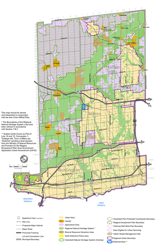
ROPA 49 updates the Regional Official Plan Map 1 and Maps 3-5 to include the following elements:
- expanding the existing Regional Urban Boundary by adding new community lands and employment lands;
- re-designating lands from North Aldershot Policy Area to Urban Area;
- recognizing lands in the Town of Milton with a “Deferred” overlay;
- removing certain employment areas in Future Strategic Employment Areas;
- identifying a broader “Corridor Protection Area” as a Highway 413 Corridor Protection Area; and
- updating the planning timeframe for Regional phasing to 2051.
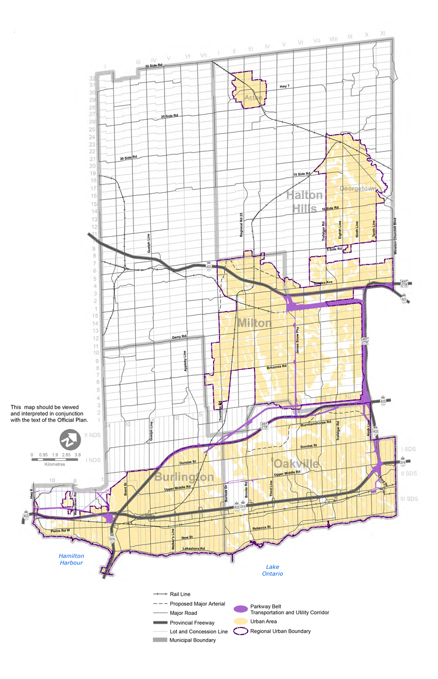
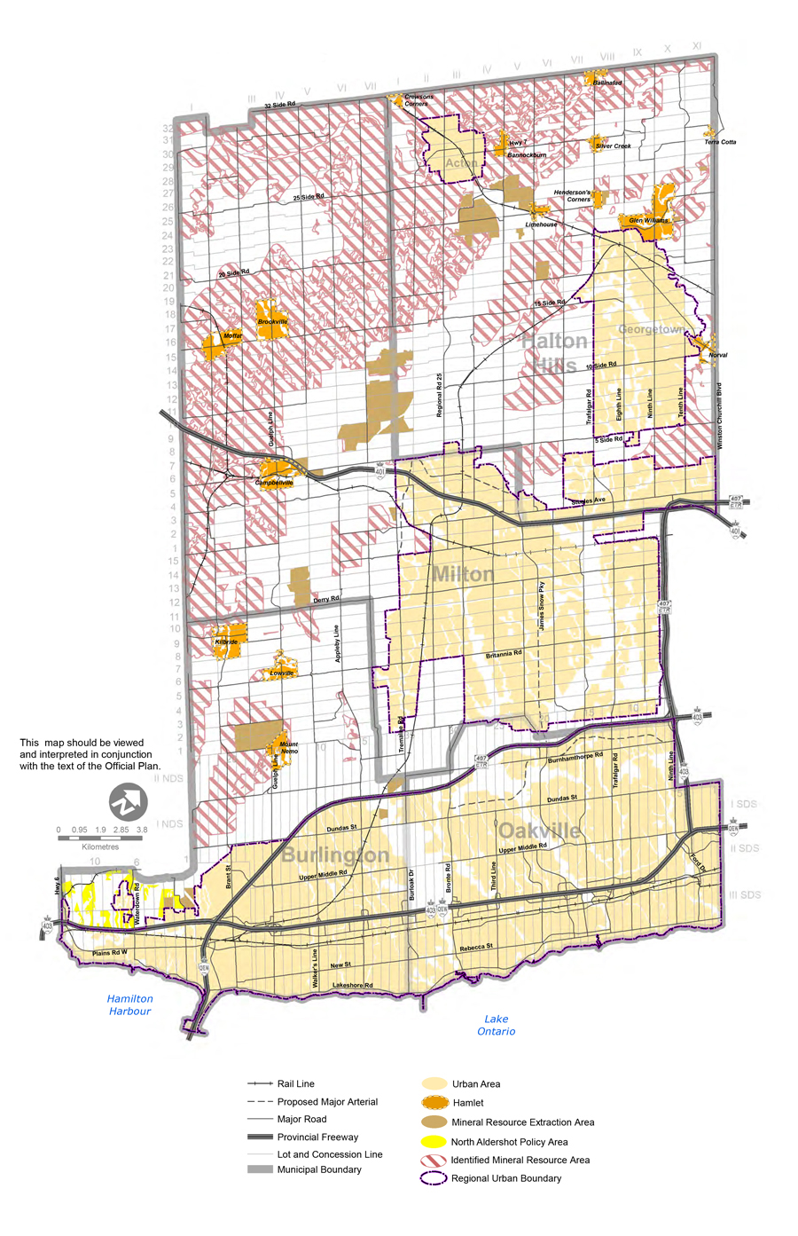
Map 1 - Regional Structure
Map 1B - Parkway Belt Transportation and Utility Corridors
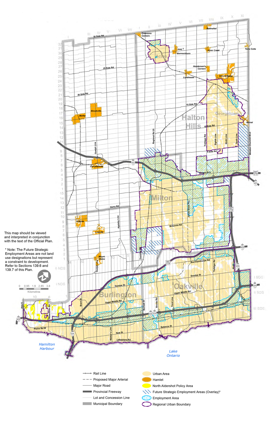
Map 1C - Future Strategic Employment Areas
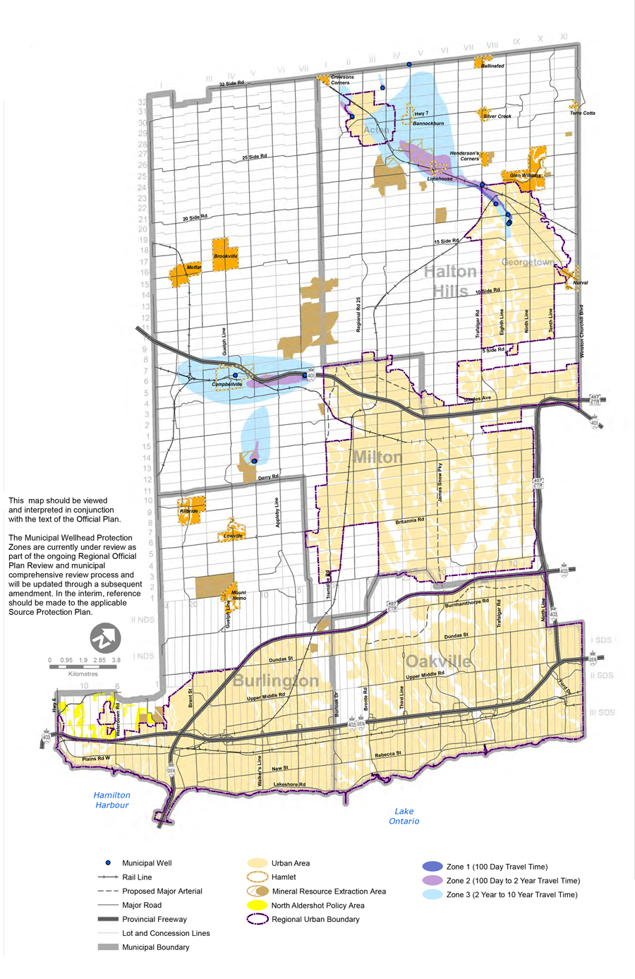
Map 1D - Municipal Wellhead Protection Zones
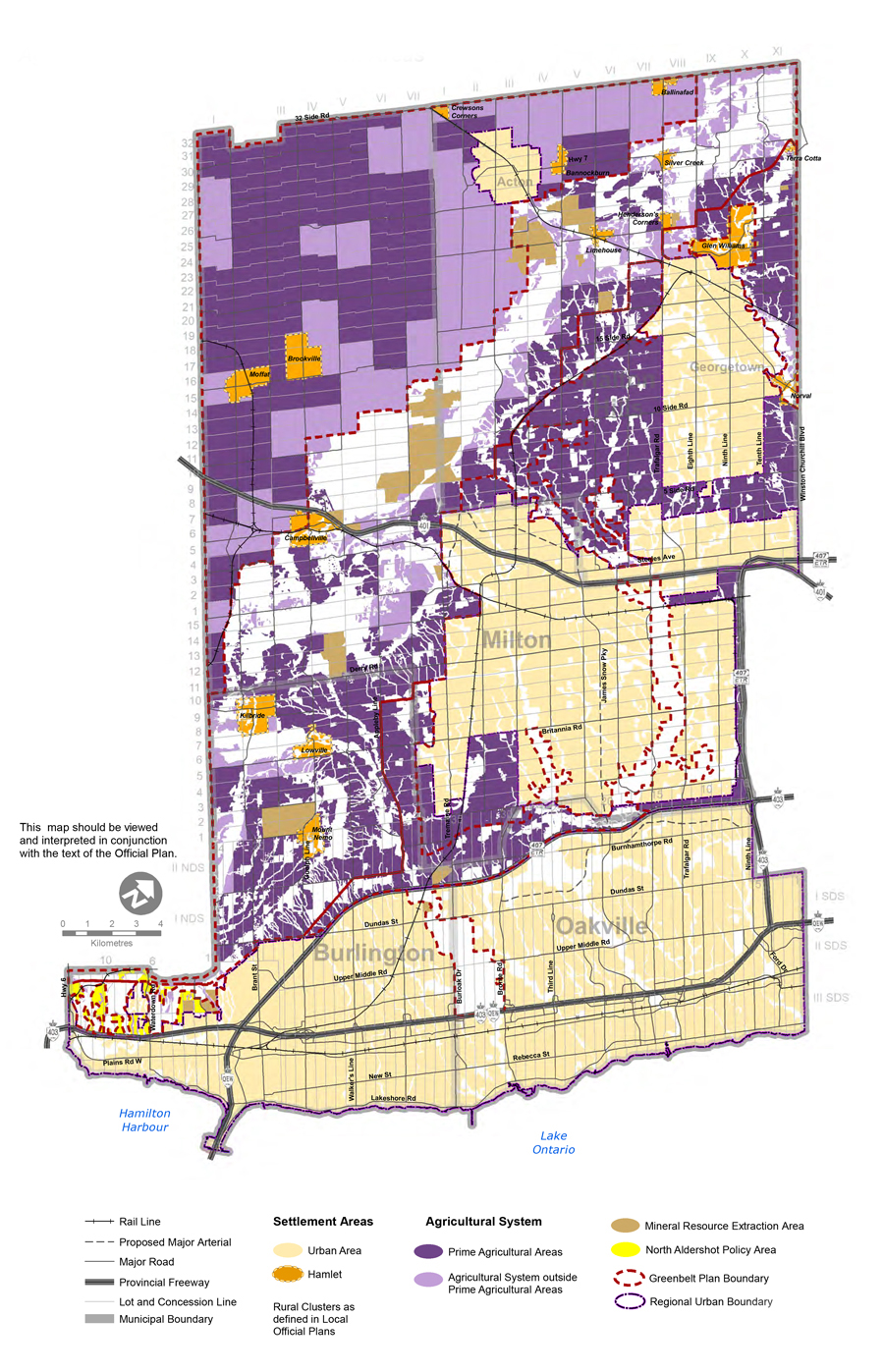
Map 1E - Agricultural System and Settlement Areas
Map 1F - Identified Mineral Resource Areas
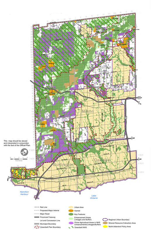
Map 1G - Key Features within the Greenbelt and Regional Natural Heritage Systems
Map 1H - Regional Urban Structure
Map 3 - Functional Plan of Major Transportation Facilities
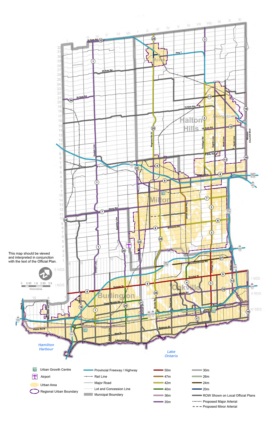
Map 4 - Right-of-Way Requirements of Arterial Roads
Map 5 - Regional Phasing
Policy Updates Document
Regional Official Plan Amendment 49 was brought forward to Regional Council on June 15, 2022 as Attachment #1 to LPS50-22: Recommendation Report - Regional Official Plan Amendment 49 (external PDF) - An Amendment to Implement the Integrated Growth Management Strategy.
Public Engagement (Completed)
Thank you to those who provided comments and submissions. The Regional Official Plan shapes how and where Halton grows—your input is valuable as we make these decisions for our community.
Virtual Public Information Centre and Statutory Public Meeting
The Public Information Centre (virtual) included a brief presentation and provided the public an opportunity to review the proposed Amendment and ask questions of staff. The Statutory Public Meeting (virtual) also included a brief presentation and provided the public with the opportunity to provide comments to Council on the proposed Amendment and for Council to consider the feedback prior to adopting the Amendment.
- Public Information Centre: Wednesday, April 6, 2022
- Statutory Public Meeting – Wednesday, April 13, 2022
Note: Pursuant to Section 17(36.5) and (38.1) of the Planning Act, the Minister’s decision on ROPA 49 is final and not subject to appeal. For more information, contact Planning Services by email at ropr@halton.ca or call 905-825-6000, ext. 7772.
To provide questions or feedback to the project team, email ropr@halton.ca or call 311. You can also sign up to receive email notifications related to the Regional Official Plan Review.